Black Witch Moths (Ascalapha odorata)
in the Eyes of Tropical Storms
---> Natural & Cultural History
<---
Records: By Year // By Date // By State // By TX County
---> Discussion of State & Provincial Records <---
Return
to Texas Entomology - Compiled by Mike
Quinn
I occasionally receive reports of Black Witch moths
near where hurricanes or tropical storms came ashore,
but only storms Claudette (2003) and Cindy (2005) generated BWMs reports in the 100s to 1000s
range.
The eye of Hurricane Claudette hit Port O'Connor, Texas
on July 15, 2003.
Here's Brush Freeman's account:
Freeman, B. 2003.
A Fallout of Black Witches
(Ascalapha odorata) Associated with Hurricane Claudette
News of the Lepidopterists' Society 45(3): 71.
"We went directly through the eye where winds dropped from ~110 mph to near 0 in just a matter of a few minutes." [...]
"As we began scanning the bay [looking for vagarant birds] we quickly became aware of large numbers of Black Witches flying over the very rough waters. We soon realized that these moths were literally everywhere, many had made landfall and were flying around the homes on the beach. More than 10 were seeking shelter in the rafters under the Hockey’s balcony alone. All in all we estimated that there must have been hundreds along the front beach or over the bay and every scope view of the bay produced one toseveral individuals." [...]
"After
the storm’s passage we were busy with clean up and repairs but not so
busy that we did not have the time to see these moths
in virtually every nook and cranny where they had sought shelter" [...]
"After
the storm’s passage we were busy with clean up and repairs but not so
busy that we did not have the time to see these moths
in virtually every nook and cranny where they had sought shelter."
Separately, John Barrow's reported after arriving at his home in Port O'Connor, "I observed 75-100 perching on my house--in the garage area--on the walls and ceiling when I arrived in POC two days after the storm passage. Would have been 7/18. Numbers diminshed each day and after 3 or 4 days they were all gone."
The following reports are from Grand Isle on the coast of Louisiana where the eye of Tropical Storm Cindy hit on July 5, 2005:
----- Sent: Thursday, July 14, 2005 8:35 AM
The eye basically passed directly over us. We had tremendous rain, substantial wind then about 2 hours of calm. Then it hit, winds from the North at 70-80mph..
----- Sent: Wednesday, July 13, 2005 10:11 AM
I wound have to say thousands, as I have been seeing numerous moths everywhere I go. And the people on the island keep calling. They think they are butterflies that escaped when the Grand Isle Butterfly Dome was destroyed in the storm. I am the editor of the local paper, and did an article on black witches, after a smaller fallout last year. I am having to educate people numerous times every day, explaining that they are not butterflies or BATS.
----- Sent: Thursday, July 07, 2005 1:51 PM
After Tropical storm/Hurricane Cindy the island is Full of Black Witch Moths
Wayne
Keller
Grand Isle Port Commission
(504) 415-0102
Both reports were made right where the eye of each storm came ashore
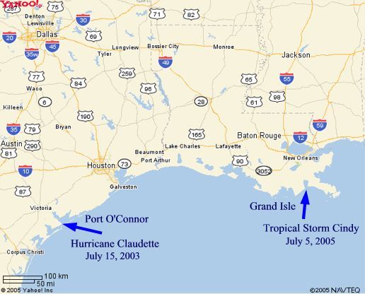
|
Arrows indicate direction and point of landfall that the eye of each storm took
Note that both Claudette and Cindy crossed Mexico's Yucatan Peninsula,
the probable source of the BWMs deposited in the U.S.


|
Dotted lines on (clickable) maps show the track that the eye of each storm took
Post Tropical Storm Cindy BWM Reports Follow the Path of the Storm
| Mississippi | Harrison Co. | Gulfport | 05 July 2005 | fresh female, clipped male, pix (seen by MAQ) |
| Mississippi | Jackson Co. | Ocean Springs | 6-8 July 2005 | ~10, photos of many (seen by MAQ) |
| Louisiana | Jefferson Parish | Grand Isle | 07 July 2005 | "Thousands" at eye of TS's landfall |
| Mississippi | Harrison Co. | Long Beach | 07 July 2005 | male observed |
| Mississippi | Harrison Co. | Gulfport | 08 July 2005 | 2 males, 2 females, in fig tree, pix (seen by MAQ) |
| Mississippi | Harrison Co. | Biloxi | 08 July 2005 | "multiple males and females" |
| Louisiana | St. Bernard Parish | Arabi | 08 July 2005 | |
| Louisiana | Plaquemines Parish | Buras/Venice | 7-8 July 2005 | Two in two days |
| Louisiana | Jefferson Parish | Marrero | 08 July 2005 | |
| Louisiana | Orleans Parish | New Orleans | 08 July 2005 | male, photo (seen by MAQ) |
| Mississippi | Harrison Co. | Pass Christian | 10 July 2005 | female, photo (seen by MAQ) |
| Louisiana | Orleans Parish | New Orleans | 11 July 2005 | 2 males, in Business District Downtown |
| Louisiana | E Baton Rouge Pa. | Baton Rouge | 16 July 2005 | worn male, photo (seen by MAQ) |
View Black Witch Moths and Huricanes in a larger map
News article on the BWMs in MS associated with TS Cindy
The Sun Herald - South Mississippi - Tim Lockley - Sat, Jul. 16, 2005
Black Witch Moths Popping Up
Prior to TS Cindy, this is the singular BWM record from Mississippi that I have specific data for:
| Mississippi | Jackson Co. | Ocean Springs | 26 Sept 2003 | fresh male, photo |
In 34 years of continuous light trapping in Louisiana, Vernon Brou (2003) collected
about 25 Black Witch specimens, with most records collected in September.
Brou, V.A., Jr. 2003.
Ascalapha odorata (L.) and Thysania zenobia (Cram.) in Louisiana.
Southern Lepidopterists' News 25(3): 91. Full PDF
Both TS Arlene and Hurricane Dennis made landfall on the northern
Gulf Coast
before and after Tropical Storm Cindy in 2005 yet no
BWMs were reported
| Landfall | Max | # of | ||
| Storm | Location | Date | Winds | BWMs |
| TS Arlene | Florida | 11 June |
70 |
0 |
| TS Cindy | Louisiana | 05 July |
70 |
1000s |
| Hurr. Dennis | Florida | 10 July |
150 |
0 |
The storm tracks of Arlene or Dennis both missed the
Yucatan Peninsula
further suggesting that Mexico was the origin of
Claudette's and Arlene's BWMs


|
Dotted lines on (clickable) maps show the track that the eye of each storm took
Illustrations of Hurricane Wind Dynamics:
vertical cross-section
http://people.cas.sc.edu/carbone/modules/mods4car/tropcycl/pages/energy.html
(move cursor over letters to see wind speeds)
horizontal cross-section
http://deepcreekyachtclub.com/WebPage/images/WindDirectionHurricane.jpg
computer model simulation of three-dimensional hurricane wind circulation
http://www.ems.psu.edu/~nese/f11_14_2.htm
Request for Help
Please report new BWM county records to entomike@gmail.com
Please include date, location (distance to nearest town) & county of record.
Also please include sex, condition of moth & prevailing weather
conditions.
If you find a new county record, please send a low resolution photo
if possible.
Thanks, Mike
15 July 2012 © Mike Quinn / entomike@gmail.com / Texas Entomology